Map for damage Assessment with Satellite Artificial Intelligence
The consortium led by Milan-based innovative SME TerrAria has been selected as one of the winners of the program in response to the humanitarian crisis in Ukraine funded by the European Space Agency, with support from the Italian Space Agency, launched in April 2022, less than two months after the start of the war. At that very difficult time of emergency management, institutions promoted the program called “Space in Response to Humanitarian Crises” by co-funding pilot projects to support humanitarian efforts in response to the Ukrainian crisis through the application of innovative geospatial technologies.
| Project Type: ESA Contract 4000142151/23/NL/EG/an, European Space Agency Budget: 604’984 Euro (483’971 Euros founded by ESA) Duration: 2023 – 2024 Number e Partners involved: 3 project partners, all Italian: TerrAria Srl (Innovative SME) – project leader, Gisky (Innovative Start-Up), EUCENTRE (non-profit organization) Role: Leader Partner Project website: https://masai-project.eu/ |
|
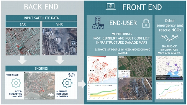
The project called MASAI (an acronym for Map for Damage Assessment with Satellite Artificial Intelligence) proposed by the consortium started in October 2023 (with a total duration of 9 months) and has enabled the creation of a web application to support regional, national and international organizations that intervene in emergency situations (humanitarian crises or natural disasters), such as the Italian Red Cross Association, the end-user of the project. MASAI leverages Artificial Intelligence (AI) techniques to identify areas damaged by the emergency, assess the degree of damage to buildings and infrastructure, estimate the extent of the area and the affected population using satellite images, and also provide an initial economic estimate of the damage. The great added value of the proposed solution was the combination of information derived from the use of space-based technologies, including the analysis of radar images processed by Gisky and optical images processed by TerrAria using artificial intelligence algorithms, with expertise in the area of vulnerability assessment of buildings and infrastructure from EUCENTRE.
THE ROLE OF TERRARIA
TerrAria was responsible for the development of the automatic machine learning algorithm for infrastructure damage identification using ultra-high resolution satellite imagery and the IT development of the geographic web platform that provides visualization and querying of radar and optical engine products, respectively. TerrAria was also dedicated to project management.