System for emergency management
The SIMULATOR project aims at providing local Public Administrations (PA) of a tool for decision support that goes in the direction of a Civil Protection 2.0. The project aims to create a prototype platform based on ICT (Information & Communications Technology) for the defence and security of the territory, with possible uses on a municipal/municipal scale.
Considering the cycle of emergencies, the SIMULATOR system supports PAs in the forecast, prevention, management and rescue phases and is able to efficiently guarantee communication between different actors: the mayor, who is in charge of managing rescue and emergency operations for civil protection events in his area; operational centres (Relief Coordination Centre, Mixed Operations Centre, Municipal Operations Centre, etc.); operational structures (Fire Brigade, Red Cross, Civil Protection Volunteers, etc.) and citizens.
The system is implemented to manage risks due to natural causes (mostly extreme events of a meteorological and seismic nature) or of anthropic origin (technological and chemical/industrial accidents). The SIMULATOR System is composed of two main elements: the CORE application which is the actual interface towards the Decider, realised as a Web Application and the VGI application (Mobile App) which is the interface towards the users PC Operator and Informed Citizens, it is the privileged channel to collect information from the territory.
THE SERVICES AND ROLE OF TERRARIA
In particular, the CORE application offers four fundamental services in the management of emergencies:
- the console dedicated to the regulatory procedure and the steps to follow in an emergency;
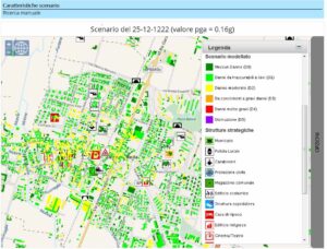
- the WebGIS, which makes available the maps with the areas at risk and the cartographic layers typical of civil protection and also allows the main environmental variables of interest acquired through instrumental monitoring and the information provided by citizens and civil protection volunteers – Human Sensor and Volunteered Geographic Information (VGI) – to be viewed;
- the module dedicated to instrumental monitoring on the territory allows the examination of temporal trends – by means of graphs – of the sensors of interest;
- the weather forecast module over the entire Lombardy territory: allows the consultation of forecast maps for temperature and precipitation for the 72 hours following the event. SIMULATOR was tested in the municipality of Tirano (hydrogeological risk) and in the municipality of Bagnolo Mella (seismic risk and industrial risk).
TerrAria was in charge of project management – both technical and administrative – of the entire project and reporting to the Lombardy Region (as lead partner). It implemented the WebGIS module, the monitoring and weather forecast module of the CORE application, and also developed the ESB (Enterprise Service Bus), which enables the communication of all the parts that make up the system.


